
Eduardo Lacerda

EduardoLacerda

Portrait of Eduardo Lacerda

Postdoctoral researcher
Conservation Biogeography Lab, Humboldt-Universität zu Berlin

I study how land use changes, using satellite time series, landscape analysis and spatial optimization, and work out where conservation and restoration do the most good. I also write the open-source software that makes this work fast and reproducible.

1985

A simulated landscape, 1985–2024. Point at any pixel to see its NDVI series and when it changed.

About

I am a Brazilian geographer and data scientist, now a postdoc in Tobias Kuemmerle’s Conservation Biogeography Lab at Humboldt-Universität zu Berlin. My work sits where remote sensing, landscape ecology and optimization meet: mapping how land changes over time, and using those maps to decide where to protect and where to restore.

From 2018 to 2023 I coordinated data science at the International Institute for Sustainability (IIS) in Rio de Janeiro. There I led the team behind PLANGEA, the institute’s spatial planning platform, and worked on the global and national restoration priorities published in Nature and elsewhere, as well as on prioritization projects for governments and companies.

Before that I spent years on monitoring and mapping: dense Landsat and Sentinel time series and change detection during my PhD at UFF, high-resolution mapping for Brazil’s Ministry of the Environment, and large spatial databases at UFRJ. That is where the software habit comes from: I have kept open-source projects on GitHub since 2015, and today I write high-performance tools in Rust, C++ and Python.

Career

  1. 2024–now
    Postdoctoral researcher Conservation Biogeography Lab, Humboldt-Universität zu Berlin

    Land-use change and deforestation frontiers; teaching Conservation Biogeography and Geoprocessing with Python.

  2. 2022–2023
    Remote sensing specialist Embrapa, Rio de Janeiro

    Harmonized Landsat and Sentinel-2 time series, image fusion and change detection.

  3. 2018–2023
    Data Science Coordinator International Institute for Sustainability (IIS), Rio de Janeiro

    Led the computational modelling and data science team and the development of PLANGEA; spatial prioritization with linear and mixed-integer programming, machine learning and HPC.

  4. 2016–2018
    Spatial database analyst Fundo Verde, COPPE/UFRJ
  5. 2014–2015
    Climate Policy Initiative, then AMS Kepler Research assistant; GIS analyst for Ministry of Environment mapping (GEOBIA, RapidEye)
  6. 2012–2018
    Researcher ESPAÇO Remote Sensing Lab, IGEO/UFRJ

    Including the Olho no Verde vegetation monitoring project with INEA.

  • 2022PhD in Geography, Universidade Federal Fluminense (UFF)
  • 2017MSc in Geography, Universidade Federal do Rio de Janeiro (UFRJ)
  • 2013BSc in Geography, Universidade do Estado do Rio de Janeiro (UERJ)

Software

Free and open-source tools for remote sensing and spatial ecology. Each reimplements the reference methods of its field, is tested against the original software, and runs from a laptop to a cluster.

Satellite time series

Zeit

Python library with a Rust core

Change detection and time series analysis for Earth observation data cubes, from STAC catalogs to maps of when, where and how much the land changed.

  • CCDC, S-CCD, LandTrendr, BFAST, BEAST, EWMACD, CODED, TWDTW
  • Phenology, unmixing, map validation, deep learning
  • Checked against the original R and author code
import zeit

ndvi = zeit.load_raster("ndvi_stack.tif")
lt   = zeit.landtrendr(ndvi)    # or ccdc, bfast…
loss = zeit.extract_events(lt)  # loss per pixel
zeit.plot(ndvi, fit=lt)
pip install zeit-cdts Documentation

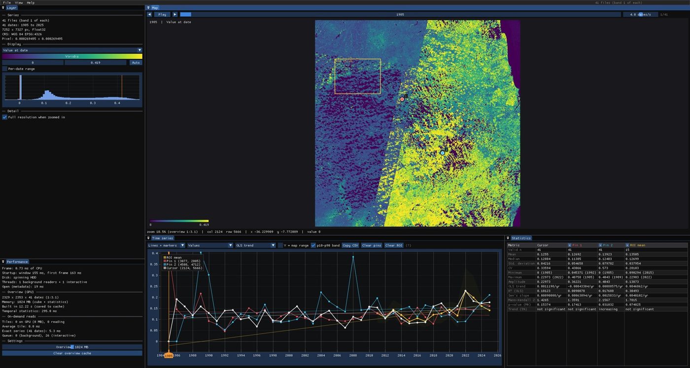
Janus

Desktop app for Windows, macOS and Linux

Janus showing a map of an NDVI cube, the time series of a pixel and its statistics

Explore satellite imagery pixel by pixel, find where and when the land changed, and measure how accurate your maps are. Opens local stacks, cloud-optimized GeoTIFFs and STAC catalogs.

Landscape ecology and conservation planning

landschaft

Python library with a C++/OpenMP core

The methods of landscape ecology in one package: habitat patterns, fragmentation, landscape metrics, connectivity and prioritization, from a single raster to maps larger than memory.

  • Reproduces GuidosToolbox, landscapemetrics, Conefor, Circuitscape, Zonation 5
  • From a few to several hundred times faster
import landschaft as ls

forest = ls.load_raster("forest.tif")
morph  = ls.mspa(forest, edge_width=2)
ls.write_raster(morph, "forest_mspa.tif")
print(ls.mspa_stats(morph))
pip install landschaft Documentation

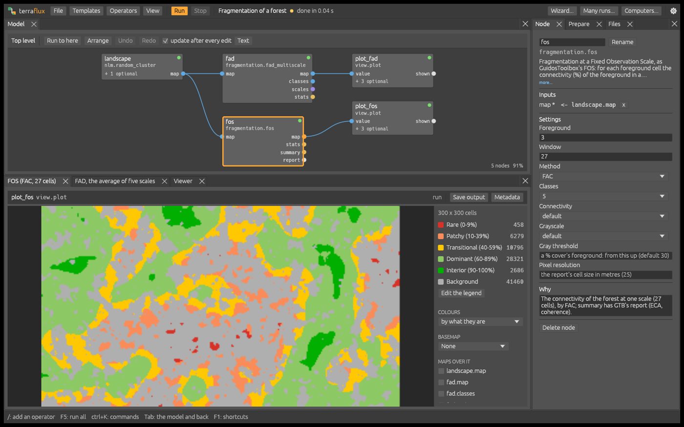
Terraflux

Desktop app and command line, written in Rust

The Terraflux model builder: a graph of operators above and the resulting forest fragmentation map below

Landscape ecology, conservation planning and land change simulation in one visual model builder: more than 340 operators and 45 ready-to-run templates, from a laptop to a Slurm cluster.

Community projects

Awesome Geospatial

A long, community-curated list of geospatial tools and resources: libraries, remote sensing, spatial databases, deep learning and more, across every major language.

stars on GitHub
5,365
forks
864

GEET

Google Earth Engine Toolbox: a JavaScript library for writing small or complex Earth Engine apps with a lot less code.

stars
177
forks
72

More projects, from Earth Engine scripts to a satellite overpass planner, are on my GitHub.

Selected publications

Work on global and national restoration priorities, biodiversity metrics, land-use change and remote sensing methods.

  1. 2026

    frontiermetrics: An R package for characterizing deforestation frontiers

    Huais, P.Y., Buchadas, A., Lacerda, E.R., Nori, J., Baumann, M., Kuemmerle, T.

    Remote Sensing in Ecology and Conservation

  2. 2025

    Addressing the urgent climate and biodiversity crisis through strategic ecosystem restoration in Brazil

    Liévano-Latorre, L.F., Almeida-Rocha, J.M., … Lacerda, E.R., … (84 authors)

    Biological Conservation

  3. 2025

    Planning for the restoration of functional connectivity in Brazil

    Manes, S., Rocha, D.S.B., Oliveira, L.G.S., … Lacerda, E.R., Latawiec, A.E., … (13 authors)

    Journal of Biogeography

  4. 2024

    Drivers of mangrove area change and suppression in Brazil from 2000 to 2020

    Vanin, G.T., Lacerda, E.R., Mori, G.M.

    Conservation Biology

  5. 2022

    Sugarcane abandonment mapping in Rio de Janeiro state Brazil

    de Castro, P.I.B., Yin, H., Teixera Junior, P.D., Lacerda, E., Pedroso, R., Lautenbach, S., Vicens, R.S.

    Remote Sensing of Environment

  6. 2021

    A metric for spatially explicit contributions to science-based species targets

    Mair, L., Bennun, L.A., Brooks, T.M., … Lacerda, E.R., … (88 authors)

    Nature Ecology & Evolution The IUCN STAR metric

  7. 2021
  8. 2020

    Global priority areas for ecosystem restoration

    Strassburg, B.B.N., Iribarrem, A., Beyer, H.L., … Lacerda, E.R., Latawiec, A.E., … Visconti, P. (27 authors)

    Nature 586, 724–729 Cited more than 1,100 times

  9. 2020

    Costs and carbon benefits of mangrove conservation and restoration: a global analysis

    Jakovac, C.C., Latawiec, A.E., Lacerda, E., Lucas, I.L., Koryś, K.A., Iribarrem, A., Malaguti, G.A., Turner, R.K., Luisetti, T., Strassburg, B.B.N.

    Ecological Economics

More than 1,500 citations across about 25 publications (OpenAlex).

Full list on ORCID, Semantic Scholar and Lattes.

Teaching

Courses I teach at the Geography Department of Humboldt-Universität zu Berlin.

Conservation Biogeography

Humboldt-Universität zu Berlin

Where biodiversity is, how land-use change threatens it, and how spatial data and planning tools help decide where to conserve and restore.

Geoprocessing with Python

Humboldt-Universität zu Berlin

Processing raster and vector data in Python, from reading and reprojecting to automating whole remote sensing and GIS workflows.